Monte Ruapehu en Nueva Zelanda. 23 de septiembre de 2021.
Un lago en la cima del volcán proporciona las principales pistas sobre lo que sucede debajo.
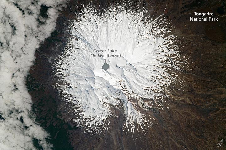
Pasando sobre la Isla Norte de Nueva Zelanda, un astronauta a bordo de la Estación Espacial Internacional (EEI) tomó una foto de Monte Ruapehu, que ofrece vistas nadir (hacia abajo) de la montaña y el Parque Nacional Tongariro. Ruapehu es un activo estratovolcán que tiene 2.797 metros (9.177 pies) de altura en su punto más alto. Es la montaña más alta de la Isla Norte.
Un estratovolcán, también llamado volcán compuesto, es un gran volcán cónico formado por muchas capas (estratos) de lava endurecida, tefra, piedra pómez y ceniza volcánica. A diferencia de los volcanes en escudo, los estratovolcanes tienen una pendiente pronunciada y erupciones explosivas ocasionales.
Se encuentran entre los tipos más comunes de volcanes, mientras que los volcanes en escudo son menos comunes. Tres de los ejemplos más famosos de estratovolcanes son el Monte Vesubio en Italia, cuya catastrófica erupción ocurrió en el año 79 d.C. BC enterró las ciudades romanas de Pompeya y Herculano; Krakatoa en Indonesia, conocido por su catastrófica erupción en 1883; y Mount St. Helens en Washington, que experimentó una gran erupción en 1980.
Cerca de la cumbre se encuentra el lago del cráter (Te Wai ā-moe), que es calentado por un sistema hidrotermal dentro del volcán. El lago permanece cálido todo el año (15 a 45 grados[{» attribute=»»>Celsius / 60 to 110 degrees Fahrenheit) and is highly acidic (pH <1). Lake temperatures usually fluctuate within this temperature range, so prolonged spikes in temperatures can signal impending volcanic activity. Because Crater Lake is the only geologically active part of the stratovolcano that is visible at the surface, changes in lake water temperatures and gas emissions are key to detecting impending volcanic activity.
Following a period of dormancy dating back to 2011, volcanic unrest was reported at Ruapehu in 2022. Moderate tremors started in March and led volcanologists to issue an alert about heightened volcanic activity. They took periodic lake temperature measurements and sulfur dioxide emission samples to monitor changes. Water temperature peaked around 40 degrees Celsius (104 degrees Fahrenheit) in May 2022, but cooled to 24 degrees Celsius (75 degrees Fahrenheit) in the following months. By July, temperatures and emissions dropped enough to lower the volcanic alert level.
During the period of unrest, a magmatic intrusion was detected beneath the volcano. The intrusion suggested that magma was rising slowly under the volcano but had halted. As a result of the magma rising, scientists suggested that the likelihood of an eruption may have increased within the Crater Lake basin.
Astronaut photograph ISS065-E-415587 was acquired on September 23, 2021, with a Nikon D5 digital camera using a focal length of 1150 millimeters. It is provided by the ISS Crew Earth Observations Facility and the Earth Science and Remote Sensing Unit, Johnson Space Center. The image was taken by a member of the Expedition 65 crew. The image has been cropped and enhanced to improve contrast, and lens artifacts have been removed. The International Space Station Program supports the laboratory as part of the ISS National Lab to help astronauts take pictures of Earth that will be of the greatest value to scientists and the public, and to make those images freely available on the Internet.
También te puede interesar
-
Los astrónomos descubren 454 nuevos asteroides en el cinturón principal
-
Los biólogos moleculares han descifrado el código de la formina
-
La NASA Juno ve un lago de lava liso como el cristal en la luna Io de Júpiter
-
Llame a fotógrafos y astrónomos de Wicklow para obtener fotografías extraordinarias
-
Cómo el pensamiento visuoespacial mejora la comprensión de la química | Noticias